
Oakland Township ZIP Code Coverage
The official state map and township address material located two postal areas that serve Oakland Township. Their descriptions are postal and geographic, not a street-by-street postal promise. A delivery label can cross the township line, and the preferred city must be checked for the actual address. The table keeps the research boundary clear by preserving the known coverage clues and the limits that still require a live USPS check.
| Postal area | Township coverage | Post office or delivery clue | Research note |
|---|---|---|---|
| 48306 | Southern and central portions, with Rochester and Rochester Hills mailing usage | Rochester/Oakland delivery context appears in local address use | Can cross municipal boundaries; verify the individual address |
| 48363 | Northern township and Goodison-area clues on the official map | Oakland/Goodison postal clue | Current delivery office and ZIP+4 must be verified per address |
No PO-box-only or single-institution postal designation serving Oakland Township was located in the official material. The complete located township-serving set is 48306 and 48363. That finding does not settle special-use delivery for a particular address, so a current USPS response remains the controlling delivery check.
Note: A state boundary map helps orient a search, but USPS controls the currently recognized delivery result for one address.
Oakland Township ZIP Code Boundaries
A ZIP code is postal geography. Oakland Township is a municipal jurisdiction inside Oakland County, while a parcel also has a situs address, mailing address, PIN, and legal description. Those layers can disagree without any error. Township and county records often use Rochester or Rochester Hills mailing labels, and a ZIP can serve addresses outside the township. A postal city therefore cannot decide township jurisdiction, parcel ownership, tax district, or the legal place of a recorded instrument.
The Michigan DTMB ZIP boundary map is the official visual geography reference. It is not a substitute for delivery validation. For one address, use the USPS ZIP lookup to check the currently recognized postal result, including the preferred city and ZIP+4 where available.
Postal-city check. Record the full address, postal city, ZIP, township, county, PIN, and legal description separately before comparing public sources.
Search Oakland Township by ZIP
There is no verified ZIP-wide official resident search for Oakland Township. That constraint is useful, because it prevents a postal code from being mistaken for a legal search filter. BS&A provides Address, Name, Parcel Number, and Building Department Record Number modes, but no ZIP-only mode was verified. Property Gateway starts with an address or PIN, while the county tax route uses a municipality plus parcel ID or a street number and street. These systems work from parcels and addresses rather than a postal area.
- Confirm the complete street address and ZIP through USPS before using any local record system.
- Use the verified address or a known PIN in BS&A or Property Gateway to locate the parcel associated with that address.
- Keep the parcel's situs, any mailing field, and legal description separate when comparing a postal label with township jurisdiction.
- Use a formal QVF request only for an authorized civic geography, such as city/township or precinct, rather than treating ZIP as a voter-file scope.
Once the address is known, the Oakland Township street directory provides the address-by-address record path. It uses parcel, map, and recorded-document tools rather than a ZIP-wide roster.
Oakland Township ZIP Property Fields
Property Gateway is the county map and parcel layer that helps test an address after a postal check. It is not a published ZIP browse tool. The portal accepts a property address or PIN, allows map browse and click, and can lead to parcel maps, aerials, elevation material, FEMA DFIRM flood information, and reports. Its partial-string and wildcard behavior can help with a road fragment, but a result still needs to be compared with the full postal address.
| Property Gateway field | Documented format or function |
|---|---|
| Property Address/PIN | At least five characters; partial text and percent wildcard accepted |
| Map browse/click | Visual selection of a parcel or road area |
| PIN | Partial PIN, percent wildcard, or comma-separated PINs |
| Report or map product | Parcel maps, aerials, elevation, FEMA DFIRM flood, tax, and landowner products |
| Delivery controls | Paper options, print scale, immediate print, PDF, pickup, standard delivery, or expedited delivery |
The Oakland County Property Gateway begins with its address and PIN search tools.
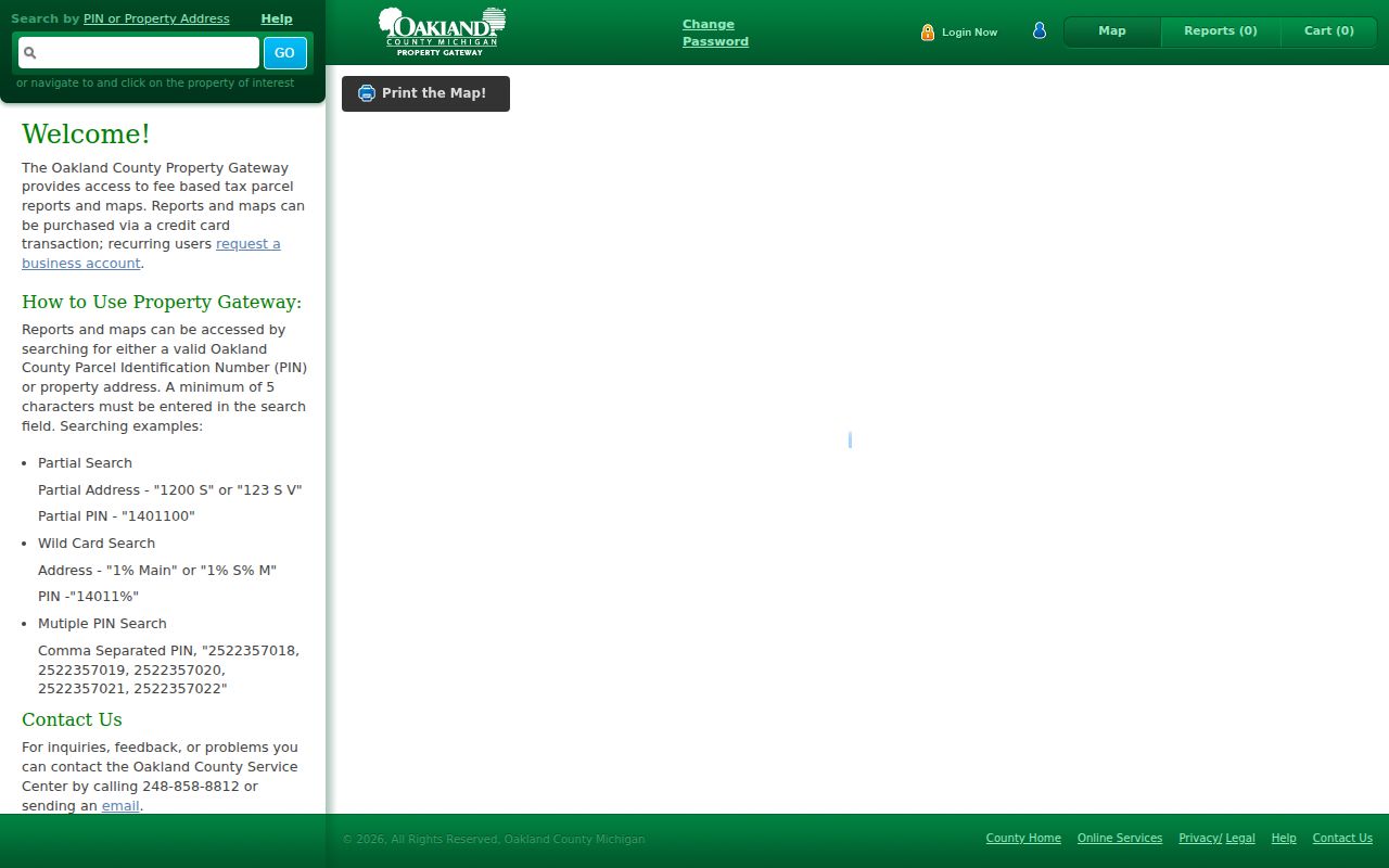
Map context can identify a parcel polygon and its public map layers, but it does not convert the portal into a ZIP code directory of people. Report fees and municipal update schedules can apply. Compare a map result with the assessor record and the official USPS response before assigning it to an Oakland Township search.
Oakland Township ZIP Civic Scope
Michigan's Qualified Voter File is also keyed to legal and civic geography, not casual ZIP searching. The formal request form allows a requester to choose one geography, including the entire state, county, city or township, several legislative districts, school, village, or specified ward or precinct. It asks for requester identity and contact details, signature and date, a delivery choice, and any requested voter-history category. It does not provide a public live ZIP search screen.
MCL 168.509gg protects or redacts listed fields, including the application office, driver-license or ID number, month and day of birth, telephone number, and digitized signature. Voter history records ballot participation, not candidate selection. A civic request can be the right source for an election question, but postal geography cannot be substituted for the form's legal scope.
Note: A ZIP may guide an address check, while a QVF request requires the specific geography and scope identified by Michigan.
Oakland Township ZIP Address Layers
Keep three versions of an Oakland Township address together when comparing sources. The situs is where the parcel lies. The mailing address is where tax correspondence is sent. The legal description or PIN is what title and assessment systems use to identify land. A deed may use section, township, range, lot, block, subdivision, or metes-and-bounds language. A current street number can change without changing that legal parcel.
The township's wooded, rural geography sits beside Rochester and Rochester Hills institutions, so one address may carry a township jurisdiction, a neighboring postal city, one of the two postal areas, an Oakland County PIN, and a different school or tax district. Each label answers a different administrative question. That layered pattern is why postal city is useful as an address clue but cannot stand in for municipal jurisdiction.
Historical searches add another layer. Township heritage material places Goodison's post office in 1874 and notes the Detroit-Bay City Railroad flag station in 1872. Newspaper, atlas, cemetery, and deed sources may therefore use Goodison, Rochester, Oakland, or Oakland Township as place headings. Test those historic names against the legal description and map context instead of converting them into a modern delivery conclusion.
Oakland Township ZIP Research Gaps
No official historic ZIP split, realignment year, or complete street-numbering timeline was located for Oakland Township. There is also no official township page that lists every road by postal station or gives a complete preferred-city crosswalk. These are evidence gaps, not reasons to assign a past postal designation to an address by inference. Check the address against current USPS results and the state boundary reference, then date any historic source separately.
The same record needs different keys in different systems. County tax search uses a municipality plus a parcel ID, or a street number and street name without the suffix. A recorded deed may instead use the PIN or legal-description language. Retaining the source date, search term, and version of the address makes it possible to revisit a result without suggesting a nonexistent postal realignment.
Property Gateway accepts partial strings, percent wildcards, and comma-separated PINs. Those useful options still operate at the parcel level, not as a postal-area browse function.
Note: No historic postal realignment or road-numbering crosswalk was verified in the official Oakland Township research.
The same caution applies to ZIP+4 and carrier information. A ZIP+4 may refine delivery for an address, but it does not alter the township's parcel boundary or title description. The official materials also did not locate a special-use or PO-box-only township ZIP. Treat any future claim about those categories as something to verify directly with USPS before relying on it.
Oakland Township ZIP Code Definitions
ZIP terms are easier to use when they are kept in their postal role. A ZIP code identifies a postal delivery area. It is not a township border, a parcel identifier, or proof of who is associated with an address. Use the official per-address check first, then follow the address or PIN into the correct county or township record system.
- ZIP versus ZIP+4
- The five-digit ZIP identifies a broad delivery area; ZIP+4 adds a more specific delivery segment for an address.
- PO-box ZIP
- A ZIP used for post-office boxes rather than a normal street-delivery area. None serving Oakland Township was located in the official research.
- Unique ZIP
- A ZIP assigned to one organization or institution. No township-serving example was located in the official research.
- Carrier route
- A postal delivery grouping used for mail handling. It does not establish a municipal or parcel boundary.
Check dates, spellings, and address components before combining a historical newspaper, a parcel map, and a postal record. A careful Oakland Township ZIP code directory keeps the differences visible instead of making a broader claim than the sources support.